Item talk:Q58980
From geokb
{
"USGS Publications Warehouse": {
"schema": {
"@context": "https://schema.org",
"@type": "CreativeWork",
"additionalType": "USGS Numbered Series",
"name": "National Land Cover Database 2001 (NLCD01)",
"identifier": [
{
"@type": "PropertyValue",
"propertyID": "USGS Publications Warehouse IndexID",
"value": "ds383",
"url": "https://pubs.usgs.gov/publication/ds383"
},
{
"@type": "PropertyValue",
"propertyID": "USGS Publications Warehouse Internal ID",
"value": 70175163
},
{
"@type": "PropertyValue",
"propertyID": "DOI",
"value": "10.3133/ds383",
"url": "https://doi.org/10.3133/ds383"
}
],
"inLanguage": "en",
"isPartOf": [
{
"@type": "CreativeWorkSeries",
"name": "Data Series"
}
],
"datePublished": "2016",
"dateModified": "2016-08-17",
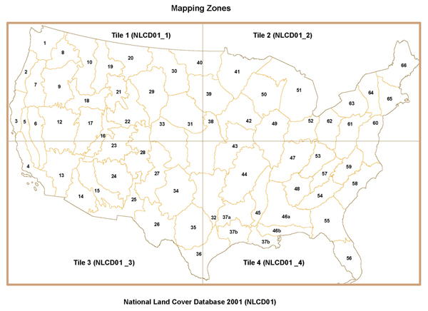
"abstract": "This 30-meter data set represents land use and land cover for the conterminous United States for the 2001 time period. The data have been arranged into four tiles to facilitate timely display and manipulation within a Geographic Information System (see http://water.usgs.gov/GIS/browse/nlcd01-partition.jpg). The National Land Cover Data Set for 2001 was produced through a cooperative project conducted by the Multi-Resolution Land Characteristics (MRLC) Consortium. The MRLC Consortium is a partnership of Federal agencies (http://www.mrlc.gov), consisting of the U.S. Geological Survey (USGS), the National Oceanic and Atmospheric Administration (NOAA), the U.S. Environmental Protection Agency (USEPA), the U.S. Department of Agriculture (USDA), the U.S. Forest Service (USFS), the National Park Service (NPS), the U.S. Fish and Wildlife Service (USFWS), the Bureau of Land Management (BLM), and the USDA Natural Resources Conservation Service (NRCS). One of the primary goals of the project is to generate a current, consistent, seamless, and accurate National Land Cover Database (NLCD) circa 2001 for the United States at medium spatial resolution. For a detailed definition and discussion on MRLC and the NLCD 2001 products, refer to Homer and others (2004), (see: http://www.mrlc.gov/mrlc2k.asp). The NLCD 2001 was created by partitioning the United States into mapping zones. A total of 68 mapping zones (see http://water.usgs.gov/GIS/browse/nlcd01-mappingzones.jpg), were delineated within the conterminous United States based on ecoregion and geographical characteristics, edge-matching features, and the size requirement of Landsat mosaics. Mapping zones encompass the whole or parts of several states. Questions about the NLCD mapping zones can be directed to the NLCD 2001 Land Cover Mapping Team at the USGS/EROS, Sioux Falls, SD (605) 594-6151 or mrlc@usgs.gov.",
"publisher": {
"@type": "Organization",
"name": "U.S. Geological Survey"
},
"author": [
{
"@type": "Person",
"name": "LaMotte, Andrew E. alamotte@usgs.gov",
"givenName": "Andrew E.",
"familyName": "LaMotte",
"email": "alamotte@usgs.gov",
"identifier": {
"@type": "PropertyValue",
"propertyID": "ORCID",
"value": "0000-0002-1434-6518",
"url": "https://orcid.org/0000-0002-1434-6518"
},
"affiliation": [
{
"@type": "Organization",
"name": "Maryland Water Science Center",
"url": "https://www.usgs.gov/centers/md-de-dc-water"
}
]
}
],
"funder": [
{
"@type": "Organization",
"name": "Maryland Water Science Center",
"url": "https://www.usgs.gov/centers/md-de-dc-water"
}
],
"spatialCoverage": [
{
"@type": "Place",
"additionalType": "country",
"name": "United States",
"url": "https://geonames.org/4074035"
},
{
"@type": "Place",
"geo": [
{
"@type": "GeoShape",
"additionalProperty": {
"@type": "PropertyValue",
"name": "GeoJSON",
"value": {
"type": "FeatureCollection",
"features": [
{
"type": "Feature",
"properties": {},
"geometry": {
"type": "Polygon",
"coordinates": [
[
[
-97.18505859374999,
25.97779895546436
],
[
-97.42675781249999,
25.878994400196202
],
[
-98.2177734375,
26.115985925333536
],
[
-99.0966796875,
26.47057302237511
],
[
-99.580078125,
27.625140335093324
],
[
-100.283203125,
28.265682390146477
],
[
-100.83251953125,
29.305561325527698
],
[
-101.27197265625,
29.592565403314087
],
[
-101.49169921875,
29.80251790576445
],
[
-102.67822265625,
29.76437737516313
],
[
-103.11767578124999,
29.036960648558267
],
[
-104.47998046875,
29.611670115197377
],
[
-104.7216796875,
29.973970240516614
],
[
-104.69970703125,
30.20211367909724
],
[
-104.9853515625,
30.675715404167743
],
[
-106.12792968749999,
31.44741029142872
],
[
-106.45751953125,
31.80289258670676
],
[
-108.21533203125,
31.784216884487385
],
[
-108.204345703125,
31.344254455668054
],
[
-110.98388671874999,
31.3348710339506
],
[
-114.82910156249999,
32.52828936482526
],
[
-114.7412109375,
32.731840896865684
],
[
-117.13623046874999,
32.54681317351514
],
[
-117.3779296875,
33.211116472416855
],
[
-118.23486328125,
33.779147331286474
],
[
-118.564453125,
34.043556504127444
],
[
-118.94897460937499,
34.052659421375964
],
[
-119.2236328125,
34.161818161230386
],
[
-119.66308593749999,
34.470335121217495
],
[
-120.44311523437499,
34.45221847282654
],
[
-120.640869140625,
34.56990638085636
],
[
-120.673828125,
35.137879119634185
],
[
-121.9482421875,
36.4566360115962
],
[
-121.83837890625,
36.721273880045004
],
[
-121.88232421875,
36.949891786813296
],
[
-122.05810546875,
36.96744946416931
],
[
-122.40966796874999,
37.23032838760387
],
[
-122.56347656249999,
37.71859032558816
],
[
-122.67333984374999,
37.90953361677018
],
[
-123.00292968749999,
37.996162679728116
],
[
-123.02490234375,
38.238180119798635
],
[
-123.74999999999999,
38.92522904714054
],
[
-123.85986328124999,
39.757879992021756
],
[
-124.365234375,
40.27952566881291
],
[
-124.4091796875,
40.463666324587685
],
[
-124.18945312500001,
41.07935114946899
],
[
-124.0576171875,
41.60722821271717
],
[
-124.29931640625,
42.00032514831621
],
[
-124.49707031249999,
42.827638636242284
],
[
-124.16748046874999,
43.83452678223684
],
[
-124.03564453125,
45.058001435398296
],
[
-124.03564453125,
46.30140615437332
],
[
-124.25537109375,
47.41322033016902
],
[
-124.62890625,
47.91634204016118
],
[
-124.69482421875,
48.4146186174932
],
[
-123.96972656249999,
48.188063481211415
],
[
-123.134765625,
48.17341248658084
],
[
-122.78320312499999,
48.246625590713826
],
[
-122.81616210937499,
48.42920055556841
],
[
-123.18969726562499,
48.50204750525715
],
[
-123.24462890625,
48.69096039092549
],
[
-122.728271484375,
48.77067246880509
],
[
-122.82714843749999,
49.001843917978526
],
[
-95.174560546875,
49.01625665778159
],
[
-95.152587890625,
49.38237278700955
],
[
-94.81201171875,
49.31796095602274
],
[
-94.669189453125,
48.777912755501845
],
[
-93.834228515625,
48.63290858589532
],
[
-93.8232421875,
48.516604348867475
],
[
-93.44970703125,
48.56752037390827
],
[
-93.33984375,
48.66194284607008
],
[
-92.59277343749999,
48.531157010976706
],
[
-92.08740234375,
48.37084770238363
],
[
-91.4501953125,
48.06339653776211
],
[
-91.07666015625,
48.19538740833338
],
[
-90.8349609375,
48.23930899024905
],
[
-90.791015625,
48.10743118848039
],
[
-89.62646484375,
48.019324184801185
],
[
-89.3463134765625,
47.98256841921402
],
[
-88.3795166015625,
48.31973404047173
],
[
-84.847412109375,
46.897739085507
],
[
-84.55078125,
46.464349400461124
],
[
-84.4134521484375,
46.49839225859763
],
[
-84.19921875,
46.53619267489863
],
[
-84.1058349609375,
46.51351558059737
],
[
-84.122314453125,
46.320378031062354
],
[
-84.00146484374999,
46.15700496290803
],
[
-83.95751953125,
46.06560846138691
],
[
-83.81469726562499,
46.11132565729796
],
[
-83.6334228515625,
46.11894150610708
],
[
-83.42468261718749,
46.0007775685566
],
[
-83.583984375,
45.82497145796607
],
[
-82.518310546875,
45.32897866218559
],
[
-82.12280273437499,
43.57243174740972
],
[
-82.40295410156249,
43.000629854450025
],
[
-82.474365234375,
42.79136972365016
],
[
-82.5732421875,
42.5611728553181
],
[
-82.8533935546875,
42.370720143531955
],
[
-83.07861328125,
42.32200108060303
],
[
-83.12255859375,
42.14304156290942
],
[
-83.14453125,
42.04521345501039
],
[
-83.07861328125,
41.86956082699455
],
[
-82.6776123046875,
41.68111756290652
],
[
-82.3974609375,
41.68111756290652
],
[
-81.243896484375,
42.21224516288584
],
[
-80.09033203125,
42.39506551565123
],
[
-78.9532470703125,
42.827638636242284
],
[
-78.91754150390625,
42.95039177450287
],
[
-79.06585693359375,
43.092960677116295
],
[
-79.06036376953125,
43.26120612479979
],
[
-79.19769287109375,
43.45291889355465
],
[
-78.6895751953125,
43.632099415557754
],
[
-76.7999267578125,
43.64005063334694
],
[
-76.4483642578125,
44.11125397357153
],
[
-75.7781982421875,
44.51609322284931
],
[
-75.30029296875,
44.84029065139799
],
[
-74.827880859375,
45.02695045318546
],
[
-71.510009765625,
45.02695045318546
],
[
-71.3232421875,
45.29034662473615
],
[
-70.653076171875,
45.42158812329091
],
[
-70.68603515625,
45.537136680398596
],
[
-70.301513671875,
45.920587344733654
],
[
-70.2685546875,
46.240651955001695
],
[
-70.059814453125,
46.40756396630067
],
[
-69.993896484375,
46.694667307773116
],
[
-69.246826171875,
47.46523622438362
],
[
-69.01611328125,
47.4355191531953
],
[
-69.0380859375,
47.26432008025478
],
[
-68.93920898437499,
47.19717795172789
],
[
-68.35693359375,
47.36115300722623
],
[
-67.763671875,
47.06263847995432
],
[
-67.78564453125,
45.706179285330855
],
[
-67.423095703125,
45.5679096098613
],
[
-67.423095703125,
45.22074260255366
],
[
-67.17041015625,
45.174292524076726
],
[
-66.961669921875,
44.85586880735725
],
[
-67.24731445312499,
44.63739123445585
],
[
-68.236083984375,
44.308126684886126
],
[
-68.258056640625,
44.20583500104184
],
[
-69.06005859375,
44.04811573082351
],
[
-69.80712890625,
43.73935207915473
],
[
-70.048828125,
43.78695837311561
],
[
-70.2081298828125,
43.73538317799622
],
[
-70.191650390625,
43.58039085560786
],
[
-70.587158203125,
43.25320494908846
],
[
-70.81787109374999,
42.89206418807337
],
[
-70.76568603515625,
42.70060440808085
],
[
-70.68603515625,
42.66426107379467
],
[
-70.63934326171875,
42.69051116998241
],
[
-70.59814453125,
42.65416193033991
],
[
-70.6585693359375,
42.589488572714245
],
[
-70.8782958984375,
42.54498667313236
],
[
-70.83984375,
42.508552415528634
],
[
-70.9771728515625,
42.44372793752476
],
[
-70.97442626953125,
42.391008609205045
],
[
-70.8343505859375,
42.26917949243506
],
[
-70.75469970703125,
42.24681856113825
],
[
-70.64208984375,
42.07783959017503
],
[
-70.5487060546875,
41.92680320648791
],
[
-70.53497314453125,
41.820455096140314
],
[
-70.42785644531249,
41.74672584176937
],
[
-70.21636962890625,
41.73852846935917
],
[
-70.0323486328125,
41.781552998900345
],
[
-70.0103759765625,
41.85319643776675
],
[
-70.0762939453125,
41.90432124806034
],
[
-70.09277343749999,
42.02889410108475
],
[
-70.16143798828125,
42.05948945192712
],
[
-70.1751708984375,
42.01869237684385
],
[
-70.24932861328125,
42.06356771883277
],
[
-70.22186279296875,
42.07987816698549
],
[
-70.13946533203124,
42.07580094787543
],
[
-70.02960205078125,
42.02889410108475
],
[
-69.96917724609375,
41.916585116228354
],
[
-69.93072509765625,
41.7856490686444
],
[
-69.93072509765625,
41.6770148220322
],
[
-69.971923828125,
41.61338889474735
],
[
-69.949951171875,
41.253032440653186
],
[
-70.11199951171875,
41.23238023874142
],
[
-70.279541015625,
41.304634388885916
],
[
-70.44158935546875,
41.347948493443546
],
[
-70.675048828125,
41.3500103516271
],
[
-70.7684326171875,
41.31494988250963
],
[
-70.7958984375,
41.29844430929419
],
[
-71.03759765625,
41.49623534616764
],
[
-71.10076904296875,
41.50034959128928
],
[
-71.180419921875,
41.46125371076149
],
[
-71.3616943359375,
41.45507852101139
],
[
-71.44683837890625,
41.43654942411456
],
[
-71.4935302734375,
41.36031866306708
],
[
-71.531982421875,
41.16004614168688
],
[
-71.97967529296874,
41.01928287604565
],
[
-72.86956787109375,
40.724364221722716
],
[
-73.33099365234375,
40.61812224225511
],
[
-73.75946044921875,
40.58267063809529
],
[
-73.92425537109375,
40.543026009954986
],
[
-73.9874267578125,
40.46993497635153
],
[
-73.96820068359375,
40.319325896602095
],
[
-74.07806396484375,
39.928694653732364
],
[
-74.1357421875,
39.631076770083666
],
[
-74.3994140625,
39.364032338047984
],
[
-74.6356201171875,
39.21948715423953
],
[
-74.8004150390625,
38.96795115401593
],
[
-74.96520996093749,
38.929502416386605
],
[
-75.07507324218749,
38.775499003812946
],
[
-75.0421142578125,
38.47939467327645
],
[
-75.16845703124999,
38.004819966413194
],
[
-75.574951171875,
37.65773212628274
],
[
-75.882568359375,
37.16907157713011
],
[
-75.9814453125,
36.88840804313823
],
[
-75.706787109375,
36.16448788632064
],
[
-75.443115234375,
35.7019167328534
],
[
-75.52001953125,
35.22767235493586
],
[
-76.00341796875,
35.10193405724606
],
[
-76.519775390625,
34.6241677899049
],
[
-76.783447265625,
34.66935854524543
],
[
-77.2119140625,
34.58799745550482
],
[
-77.596435546875,
34.37064492478658
],
[
-77.87109375,
34.043556504127444
],
[
-77.93701171875,
33.797408767572485
],
[
-78.167724609375,
33.87041555094183
],
[
-78.662109375,
33.8430453147447
],
[
-79.013671875,
33.568861182555565
],
[
-79.156494140625,
33.32134852669881
],
[
-79.1455078125,
33.201924189778936
],
[
-79.69482421875,
32.7872745269555
],
[
-80.43090820312499,
32.47269502206151
],
[
-80.44189453125,
32.32427558887655
],
[
-80.83740234375,
32.0732655510424
],
[
-81.265869140625,
31.42866311735861
],
[
-81.419677734375,
30.760718908944472
],
[
-81.34277343749999,
29.99300228455108
],
[
-80.936279296875,
29.1233732108192
],
[
-80.52978515625,
28.488005204159457
],
[
-80.606689453125,
28.372068829631633
],
[
-80.474853515625,
27.848790459862073
],
[
-80.068359375,
26.95145308349826
],
[
-80.079345703125,
26.2145910237943
],
[
-80.167236328125,
25.37380917154398
],
[
-80.79345703125,
24.87646991083154
],
[
-80.9033203125,
24.856534339310674
],
[
-81.177978515625,
25.21488107113259
],
[
-81.2548828125,
25.54244147012483
],
[
-81.551513671875,
25.878994400196202
],
[
-81.67236328125,
25.86910939099931
],
[
-81.89208984375,
26.441065564038418
],
[
-82.11181640625,
26.43122806450644
],
[
-82.298583984375,
26.833874515058554
],
[
-82.63916015625,
27.371767300523047
],
[
-82.869873046875,
27.89734922968426
],
[
-82.72705078125,
28.391400375817753
],
[
-82.7490234375,
29.046565622728846
],
[
-83.023681640625,
29.180941290001776
],
[
-83.8916015625,
30.0405664305846
],
[
-84.3310546875,
30.097613277217132
],
[
-84.320068359375,
29.907329376851553
],
[
-85.05615234375,
29.592565403314087
],
[
-85.36376953125,
29.66896252599253
],
[
-86.02294921875,
30.29701788337205
],
[
-87.03369140625,
30.372875188118016
],
[
-88.17626953125,
30.221101852485987
],
[
-89.27490234375,
30.240086360983426
],
[
-89.31884765624999,
29.76437737516313
],
[
-89.47265625,
29.554345125748267
],
[
-88.9013671875,
29.267232865200878
],
[
-89.27490234375,
28.8831596093235
],
[
-89.69238281249999,
29.209713225868185
],
[
-90.2197265625,
29.075375179558346
],
[
-91.01074218749999,
29.0945770775118
],
[
-91.4501953125,
29.34387539941801
],
[
-92.46093749999999,
29.53522956294847
],
[
-93.44970703125,
29.726222319395504
],
[
-94.52636718749999,
29.477861195816843
],
[
-95.2294921875,
29.05616970274342
],
[
-96.064453125,
28.5941685062326
],
[
-96.767578125,
28.16887518006332
],
[
-97.27294921875,
27.68352808378776
],
[
-97.3388671875,
26.980828590472107
],
[
-97.18505859374999,
25.97779895546436
]
]
]
}
}
]
}
}
},
{
"@type": "GeoCoordinates",
"latitude": 39.505747259696946,
"longitude": -99.00054945623889
}
]
}
]
}
},
"OpenAlex": {
"abstract_inverted_index": {
"This": [
0
],
"30-meter": [
1
],
"data": [
2,
21
],
"set": [
3
],
"represents": [
4
],
"land": [
5,
8
],
"use": [
6
],
"and": [
7,
32,
83,
112,
122,
145,
166,
170,
178,
214,
219
],
"cover": [
9
],
"for": [
10,
15,
47,
154
],
"the": [
11,
16,
57,
75,
80,
87,
93,
99,
104,
109,
116,
123,
132,
136,
155,
171,
190,
207,
220,
229,
238,
246,
254
],
"conterminous": [
12,
208
],
"United": [
13,
156,
191,
209
],
"States": [
14,
157,
192,
210
],
"2001": [
17,
48,
153,
173,
185,
248
],
"time": [
18
],
"period.": [
19
],
"The": [
20,
41,
63,
183
],
"have": [
22
],
"been": [
23
],
"arranged": [
24
],
"into": [
25,
193
],
"four": [
26
],
"tiles": [
27
],
"to": [
28,
139,
176,
245
],
"facilitate": [
29
],
"timely": [
30
],
"display": [
31
],
"manipulation": [
33
],
"within": [
34,
206
],
"a": [
35,
52,
67,
141,
163
],
"Geographic": [
36
],
"Information": [
37
],
"System": [
38
],
"(see": [
39,
202
],
"http://water.usgs.gov/GIS/browse/nlcd01-partition.jpg).": [
40
],
"National": [
42,
81,
105,
147
],
"Land": [
43,
59,
119,
148,
249
],
"Cover": [
44,
149,
250
],
"Data": [
45
],
"Set": [
46
],
"was": [
49,
186
],
"produced": [
50
],
"through": [
51
],
"cooperative": [
53
],
"project": [
54,
137
],
"conducted": [
55
],
"by": [
56,
188
],
"Multi-Resolution": [
58
],
"Characteristics": [
60
],
"(MRLC)": [
61
],
"Consortium.": [
62
],
"MRLC": [
64,
169
],
"Consortium": [
65
],
"is": [
66,
138
],
"partnership": [
68
],
"of": [
69,
74,
96,
118,
131,
135,
198,
223,
233
],
"Federal": [
70
],
"agencies": [
71
],
"(http://www.mrlc.gov),": [
72
],
"consisting": [
73
],
"U.S.": [
76,
88,
94,
100,
110
],
"Geological": [
77
],
"Survey": [
78
],
"(USGS),": [
79
],
"Oceanic": [
82
],
"Atmospheric": [
84
],
"Administration": [
85
],
"(NOAA),": [
86
],
"Environmental": [
89
],
"Protection": [
90
],
"Agency": [
91
],
"(USEPA),": [
92
],
"Department": [
95
],
"Agriculture": [
97
],
"(USDA),": [
98
],
"Forest": [
101
],
"Service": [
102,
107,
114,
128
],
"(USFS),": [
103
],
"Park": [
106
],
"(NPS),": [
108
],
"Fish": [
111
],
"Wildlife": [
113
],
"(USFWS),": [
115
],
"Bureau": [
117
],
"Management": [
120
],
"(BLM),": [
121
],
"USDA": [
124
],
"Natural": [
125
],
"Resources": [
126
],
"Conservation": [
127
],
"(NRCS).": [
129
],
"One": [
130
],
"primary": [
133
],
"goals": [
134
],
"generate": [
140
],
"current,": [
142
],
"consistent,": [
143
],
"seamless,": [
144
],
"accurate": [
146
],
"Database": [
150
],
"(NLCD)": [
151
],
"circa": [
152
],
"at": [
158,
253
],
"medium": [
159
],
"spatial": [
160
],
"resolution.": [
161
],
"For": [
162
],
"detailed": [
164
],
"definition": [
165
],
"discussion": [
167
],
"on": [
168,
212
],
"NLCD": [
172,
184,
239,
247
],
"products,": [
174
],
"refer": [
175
],
"Homer": [
177
],
"others": [
179
],
"(2004),": [
180
],
"(see:": [
181
],
"http://www.mrlc.gov/mrlc2k.asp).": [
182
],
"created": [
187
],
"partitioning": [
189
],
"mapping": [
194,
200,
240
],
"zones.": [
195
],
"A": [
196
],
"total": [
197
],
"68": [
199
],
"zones": [
201,
227,
241
],
"http://water.usgs.gov/GIS/browse/nlcd01-mappingzones.jpg),": [
203
],
"were": [
204
],
"delineated": [
205
],
"based": [
211
],
"ecoregion": [
213
],
"geographical": [
215
],
"characteristics,": [
216
],
"edge-matching": [
217
],
"features,": [
218
],
"size": [
221
],
"requirement": [
222
],
"Landsat": [
224
],
"mosaics.": [
225
],
"Mapping": [
226,
251
],
"encompass": [
228
],
"whole": [
230
],
"or": [
231,
261
],
"parts": [
232
],
"several": [
234
],
"states.": [
235
],
"Questions": [
236
],
"about": [
237
],
"can": [
242
],
"be": [
243
],
"directed": [
244
],
"Team": [
252
],
"USGS/EROS,": [
255
],
"Sioux": [
256
],
"Falls,": [
257
],
"SD": [
258
],
"(605)": [
259
],
"594-6151": [
260
],
"mrlc@usgs.gov.": [
262
]
},
"apc_list": null,
"apc_paid": null,
"authorships": [
{
"author_position": "first",
"author": {
"id": "https://openalex.org/A5027903327",
"display_name": "Andrew E. LaMotte",
"orcid": "https://orcid.org/0000-0002-1434-6518"
},
"institutions": [],
"countries": [],
"is_corresponding": true,
"raw_author_name": "Andrew E. LaMotte",
"raw_affiliation_strings": [],
"affiliations": []
}
],
"best_oa_location": null,
"biblio": {
"volume": null,
"issue": null,
"first_page": null,
"last_page": null
},
"citation_normalized_percentile": {
"value": 0.891873,
"is_in_top_1_percent": false,
"is_in_top_10_percent": false
},
"cited_by_api_url": "https://api.openalex.org/works?filter=cites:W2524451732",
"cited_by_count": 51,
"cited_by_percentile_year": {
"min": 96,
"max": 97
},
"concepts": [
{
"id": "https://openalex.org/c2776191655",
"wikidata": "https://www.wikidata.org/wiki/Q295469",
"display_name": "Ecoregion",
"level": 2,
"score": 0.8474097,
"qid": null
},
{
"id": "https://openalex.org/c2781113848",
"wikidata": "https://www.wikidata.org/wiki/Q2915366",
"display_name": "Geological survey",
"level": 2,
"score": 0.75041705,
"qid": null
},
{
"id": "https://openalex.org/c2780648208",
"wikidata": "https://www.wikidata.org/wiki/Q3001793",
"display_name": "Land cover",
"level": 3,
"score": 0.6701356,
"qid": null
},
{
"id": "https://openalex.org/c2780993040",
"wikidata": "https://www.wikidata.org/wiki/Q46169",
"display_name": "National park",
"level": 2,
"score": 0.56883335,
"qid": null
},
{
"id": "https://openalex.org/c205649164",
"wikidata": "https://www.wikidata.org/wiki/Q1071",
"display_name": "Geography",
"level": 0,
"score": 0.5680515,
"qid": "Q158983"
},
{
"id": "https://openalex.org/c559400886",
"wikidata": "https://www.wikidata.org/wiki/Q2001056",
"display_name": "Land management",
"level": 3,
"score": 0.4614116,
"qid": null
},
{
"id": "https://openalex.org/c77088390",
"wikidata": "https://www.wikidata.org/wiki/Q8513",
"display_name": "Database",
"level": 1,
"score": 0.44464555,
"qid": "Q165904"
},
{
"id": "https://openalex.org/c107826830",
"wikidata": "https://www.wikidata.org/wiki/Q929380",
"display_name": "Environmental resource management",
"level": 1,
"score": 0.4030156,
"qid": "Q226238"
},
{
"id": "https://openalex.org/c4792198",
"wikidata": "https://www.wikidata.org/wiki/Q1165944",
"display_name": "Land use",
"level": 2,
"score": 0.33968365,
"qid": null
},
{
"id": "https://openalex.org/c39432304",
"wikidata": "https://www.wikidata.org/wiki/Q188847",
"display_name": "Environmental science",
"level": 0,
"score": 0.2630524,
"qid": "Q166085"
},
{
"id": "https://openalex.org/c118518473",
"wikidata": "https://www.wikidata.org/wiki/Q11451",
"display_name": "Agriculture",
"level": 2,
"score": 0.21799883,
"qid": "Q166198"
},
{
"id": "https://openalex.org/c41008148",
"wikidata": "https://www.wikidata.org/wiki/Q21198",
"display_name": "Computer science",
"level": 0,
"score": 0.1673891,
"qid": "Q158969"
},
{
"id": "https://openalex.org/c18903297",
"wikidata": "https://www.wikidata.org/wiki/Q7150",
"display_name": "Ecology",
"level": 1,
"score": 0.15749535,
"qid": "Q158972"
},
{
"id": "https://openalex.org/c166957645",
"wikidata": "https://www.wikidata.org/wiki/Q23498",
"display_name": "Archaeology",
"level": 1,
"score": 0.09530151,
"qid": "Q226195"
},
{
"id": "https://openalex.org/c127313418",
"wikidata": "https://www.wikidata.org/wiki/Q1069",
"display_name": "Geology",
"level": 0,
"score": 0.09116137,
"qid": "Q158984"
},
{
"id": "https://openalex.org/c151730666",
"wikidata": "https://www.wikidata.org/wiki/Q7205",
"display_name": "Paleontology",
"level": 1,
"score": 0.0,
"qid": "Q159017"
},
{
"id": "https://openalex.org/c86803240",
"wikidata": "https://www.wikidata.org/wiki/Q420",
"display_name": "Biology",
"level": 0,
"score": 0.0,
"qid": "Q158998"
}
],
"corresponding_author_ids": [
"https://openalex.org/A5027903327"
],
"corresponding_institution_ids": [],
"countries_distinct_count": 0,
"counts_by_year": [
{
"year": 2024,
"cited_by_count": 3
},
{
"year": 2023,
"cited_by_count": 8
},
{
"year": 2022,
"cited_by_count": 2
},
{
"year": 2021,
"cited_by_count": 4
},
{
"year": 2019,
"cited_by_count": 4
},
{
"year": 2018,
"cited_by_count": 2
},
{
"year": 2017,
"cited_by_count": 6
},
{
"year": 2016,
"cited_by_count": 1
},
{
"year": 2015,
"cited_by_count": 1
},
{
"year": 2014,
"cited_by_count": 6
},
{
"year": 2013,
"cited_by_count": 7
},
{
"year": 2012,
"cited_by_count": 2
}
],
"created_date": "2016-10-07",
"datasets": [],
"display_name": "National Land Cover Database 2001 (NLCD01)",
"doi": "https://doi.org/10.3133/ds383",
"fwci": 2.723,
"grants": [],
"has_fulltext": false,
"id": "https://openalex.org/W2524451732",
"ids": {
"openalex": "https://openalex.org/W2524451732",
"doi": "https://doi.org/10.3133/ds383",
"mag": "2524451732"
},
"indexed_in": [
"crossref"
],
"institutions_distinct_count": 0,
"is_paratext": false,
"is_retracted": false,
"keywords": [
{
"id": "https://openalex.org/keywords/ecoregion",
"display_name": "Ecoregion",
"score": 0.8474097
},
{
"id": "https://openalex.org/keywords/geological-survey",
"display_name": "Geological survey",
"score": 0.75041705
},
{
"id": "https://openalex.org/keywords/land-cover",
"display_name": "Land Cover",
"score": 0.545379
}
],
"language": "en",
"locations": [
{
"is_oa": false,
"landing_page_url": "https://doi.org/10.3133/ds383",
"pdf_url": null,
"source": {
"id": "https://openalex.org/S4210176622",
"display_name": "Data series",
"issn_l": "2327-638X",
"issn": [
"2327-638X",
"2328-0271",
"2333-0481"
],
"is_oa": false,
"is_in_doaj": false,
"is_core": false,
"host_organization": "https://openalex.org/P4310319934",
"host_organization_name": "United States Geological Survey",
"host_organization_lineage": [
"https://openalex.org/P4310319934",
"https://openalex.org/P4310316088"
],
"host_organization_lineage_names": [
"United States Geological Survey",
"United States Department of the Interior"
],
"type": "journal"
},
"license": null,
"license_id": null,
"version": null,
"is_accepted": false,
"is_published": false
}
],
"locations_count": 1,
"mesh": [],
"ngrams_url": "https://api.openalex.org/works/W2524451732/ngrams",
"open_access": {
"is_oa": false,
"oa_status": "closed",
"oa_url": null,
"any_repository_has_fulltext": false
},
"primary_location": {
"is_oa": false,
"landing_page_url": "https://doi.org/10.3133/ds383",
"pdf_url": null,
"source": {
"id": "https://openalex.org/S4210176622",
"display_name": "Data series",
"issn_l": "2327-638X",
"issn": [
"2327-638X",
"2328-0271",
"2333-0481"
],
"is_oa": false,
"is_in_doaj": false,
"is_core": false,
"host_organization": "https://openalex.org/P4310319934",
"host_organization_name": "United States Geological Survey",
"host_organization_lineage": [
"https://openalex.org/P4310319934",
"https://openalex.org/P4310316088"
],
"host_organization_lineage_names": [
"United States Geological Survey",
"United States Department of the Interior"
],
"type": "journal"
},
"license": null,
"license_id": null,
"version": null,
"is_accepted": false,
"is_published": false
},
"primary_topic": {
"id": "https://openalex.org/T13388",
"display_name": "Factors Affecting Sagebrush Ecosystems and Wildlife Conservation",
"score": 0.9853,
"subfield": {
"id": "https://openalex.org/subfields/2303",
"display_name": "Ecology"
},
"field": {
"id": "https://openalex.org/fields/23",
"display_name": "Environmental Science"
},
"domain": {
"id": "https://openalex.org/domains/3",
"display_name": "Physical Sciences"
}
},
"publication_date": "2016-01-01",
"publication_year": 2016,
"referenced_works": [],
"referenced_works_count": 0,
"related_works": [
"https://openalex.org/W849327309",
"https://openalex.org/W83404948",
"https://openalex.org/W37290118",
"https://openalex.org/W3087837298",
"https://openalex.org/W2910429312",
"https://openalex.org/W2400855259",
"https://openalex.org/W2264740107",
"https://openalex.org/W2157135907",
"https://openalex.org/W2119077941",
"https://openalex.org/W1978193949"
],
"sustainable_development_goals": [],
"title": "National Land Cover Database 2001 (NLCD01)",
"topics": [
{
"id": "https://openalex.org/T13388",
"display_name": "Factors Affecting Sagebrush Ecosystems and Wildlife Conservation",
"score": 0.9853,
"subfield": {
"id": "https://openalex.org/subfields/2303",
"display_name": "Ecology"
},
"field": {
"id": "https://openalex.org/fields/23",
"display_name": "Environmental Science"
},
"domain": {
"id": "https://openalex.org/domains/3",
"display_name": "Physical Sciences"
}
},
{
"id": "https://openalex.org/T14468",
"display_name": "Analysis of Land Cover and Ecosystems",
"score": 0.9411,
"subfield": {
"id": "https://openalex.org/subfields/2303",
"display_name": "Ecology"
},
"field": {
"id": "https://openalex.org/fields/23",
"display_name": "Environmental Science"
},
"domain": {
"id": "https://openalex.org/domains/3",
"display_name": "Physical Sciences"
}
},
{
"id": "https://openalex.org/T10757",
"display_name": "Volunteered Geographic Information and Geospatial Crowdsourcing",
"score": 0.936,
"subfield": {
"id": "https://openalex.org/subfields/3305",
"display_name": "Geography, Planning and Development"
},
"field": {
"id": "https://openalex.org/fields/33",
"display_name": "Social Sciences"
},
"domain": {
"id": "https://openalex.org/domains/2",
"display_name": "Social Sciences"
}
}
],
"type": "article",
"type_crossref": "journal-article",
"updated_date": "2024-08-10T08:22:04.121031",
"versions": [],
"qid": "Q58980"
}
}